Kanchanpur District
 |
| Dodhara Chadani Jholunge pul |
Only a few decades ago, Kanchanpur was a malarial forest inhabited by the indigenous Tharus. But today, it has become heterogeneous. In 1871,the Tharus represented 43 percent of the total population; in 1991 the proportion, despite immigration, stood at only 27 percent. The Tharus are swamped by non-Tharu migrants from the hills. The hill tribes in the district composed of Brahman (15%), Chhetri (28%), Kami(10%), and Sarki (13%). Others include Thakuri, Sanyasy, Tamang, Magar and Damai. The overall literacy rate of Kanchanpur is 59.3 percent – female 45.2 percent in 1999, the latter being higher than the national average. However, 27 percent children between 6 to 10 years.
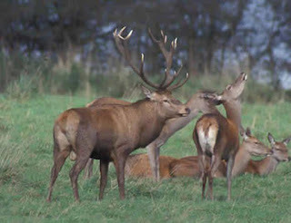
Shuklaphanta Reserve This wildlife reserve is situated in the extreme southwest of Nepal, along the eastern bend of the Mahakali River. There are series of large and small grasslands fringed by forest made up primarily of sal. The name of the park is derived from the largest of this grassland which is known as Sukla Phanta. The park area of 155 sq. km was originally the hunting grounds for the one-time Rana rulers of Nepal.Sukla Phanta’s grassland is one of the last remaining habitat for endangered animals such as hispid hare and the pygmy hog. Besides these, Sukla Phanta is the stronghold for another endangered animal, the Barasingha, or swamp deer. The grassy conditions seem to be ideal for the large deer and their number has been dramatically increased to more than 2,000 in recent times.
 |
| Swamp deer |
Other wildlife of the park includes spotted deer, also seen in large numbers, hog deer, nilgai, wild dog, jackal, porcupine and otter. The park and the adjoining forest is the territory of small number of tigers which because of open terrain are not uncommon to sight on the prowl. Wild elephants were also sighted in park. According to local villagers, they are attracted by the rice crops during the monsoon season.
A stop at the Rani Tal (Rani Lake) is a must. This small lake attracts birds and animals alike. Herons, ducks, storks, kingfisher and egrets vie for food and swamp deer wallow at the edges. One can watch thousands of water fowl mingling on the lake surface while it is not uncommon to see hundreds of swamp deer grazing at the water-edge in the evening light. The experience is unique. Few tourists have visited the lesser-known trails of western Nepal, in spite of the presence of the Royal Bardiya Reserve. The Mahendra Highway, linking east and west, will inevitably encourage more visitors to the region.
 |
| Rani taal in Shuklaphanta Wildlife Reserve |
Karnali, part of the Royal Bardiya Reserve, located on the eastern bank of the Karnali River, is a sanctuary for the endangered swamp deer. Tiger Tops runs Karnali Tent Camp, with accommodation for up to 16 guests. Shukla Phanta in Kanchanpur district, in the westernmost reaches of Nepal, is one of the few places in the country where the endangered blackbuck is found. Other ways to view wildlife in the park is by driving in land rovers near the lake and river, and on nature walks with trained trackers. Accommodation and outing are best prearranged through agents in Kathmandu. Visitors should travel with tents, food and transport.Mahendranagar: Mahendranagar, about 270 meters about sea level, is a new settlement in the middle of a forest with the foothills visible to the north. The place was first cleared in 1962 when the district headquarters was shifted here from Belauri on the southern border. The main east-west street is lined up by a group of new houses made from plentiful timber. There are about two dozen shops. Apart from the hataru (marketer) from Dadeldhura, Doti and Baitadi, the place is already swarmed with squatters from the hills. The place has easy link with Tanakpur railhead, about an hour’s walk to the west. It is one of the major commercial place in the region. Moreover, as the zonal headquarters with 29 government offices, Mahendranagar claims primacy in managing the affairs of the entire Mahakali Zone that extends as far as 154 kilometers to the north.Dhami Pratha: The Dhami partha (Shamanism) is common in the region and decision he makes is
acceptable to people as a word from god.
Access:There are daily/weekly air flights from Kathmandu to the nearby Dhangadhi airstrip. Bus service from Kathmandu and eastern part of Nepal is regular. The best time to visit is from November to April.
General Information
Headquarters: Mahendranagar
Area: 1610 km²
Total Population:451,248
Literacy rate: 57.60% (Male, 70.53%; Female, 44.19%)
Political constituencies: 4Total no. of Municipalities: 1 (Mahendranagar – eighth-biggest city of Nepal)
Political Boundary
East: Kailali and Doti
West: India
North: Daleldhura
South: India
Major rivers
Mahakali, Syauli, Chaughar, Wahamani, Chandar.Longitude: 800 3"- 800 33"
Latitude: 280 32"-290 8"
Climate
Temperature Maximum: 30.50 °Centigrade
Temperature Minimum: 17.50 °Centigrade
Rainfall 1422.7 ml.
Predominant Language and Culture
Tourist attraction centers
Dodhara Chandani Belly Bridge, Mahendranagar, Belauri, Betkot picnic spot , Rani Tal, Shuklaphanta Wildlife Reserve.
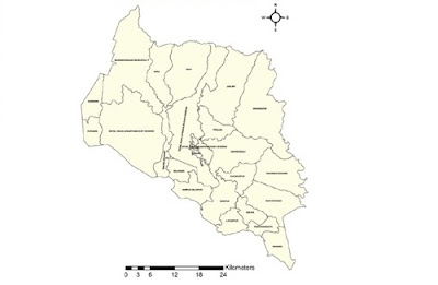
Map Of Kanchanpur District
Town and Village
- Baise Bichwa
- Beldandi
- Chandani
- Daijee
- Dekhatbhuli
- Dodhara
- Jhalari
- Kalika
- Krishnapur
- Laxmipur
- Parasan
- Pipaladi
- Raikawar Bichawa
- Rampur Bilaspur
- Rauteli Bichawa
- Sankarpur
- Sreepur
- Suda
- Tribhuwanbasti


Comments
Post a Comment